
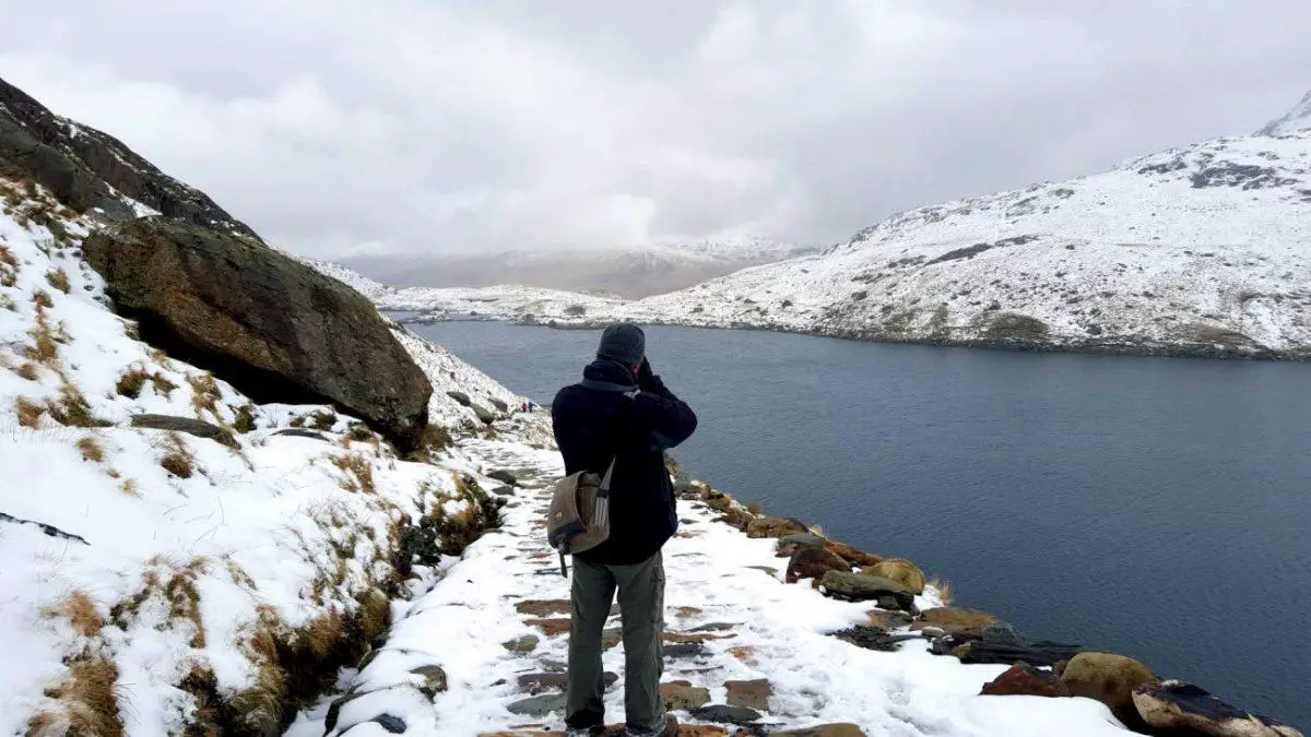
The one thing that trumped everything else we did in Snowdonia was our winter hike up the Miners’ Track to Mount Snowdon.
Climbing Snowdon has always been Gary’s dream and has featured heavily on his bucket list. In fact, he enjoys stating that he will propose to me at the top of Mount Kilimanjaro.
I on the other hand, am the first to admit that I’m not the fittest in the world. A keen mountaineer in my youth in recent years a lack of hiking has meant that I have lost almost all of my skills. Add to that my ever increasing fear of heights and the fact that I had a massive chest infection the week before – and you might understand why I was dreading climbing to the top of Snowdon.
I found it difficult. I’m not going to lie. But in the end, I am glad that Visit Wales challenged me to Find my Epic.
There are numerous ways up the mountain. In summer, there is even the option of hopping onto a train. Choosing the right path was difficult and took us a while. There are differing opinions on the web about the difficulty of each path. In the end, they opted to follow the miner’s track. To be honest it was the best choice we could have made.
LOCATION

HISTORY OF SNOWDON’S MINERS’ TRACK
The Miners Path was originally built to carry copper from the Britannia Copper Works near Llyn Glaslyn to Pen y Pass. From here it was transported all the way to Caernarfon.
Although the Miners’ Track was built to serve the Britannia Copper Mine, it was not the first route used by the miners. Before the track was built, miners had to lug the copper up the eastern side of the mountain. From here it was drawn on a sledge by two horses all the way to Llyn Cwellyn.
The mine manager, Arthur Lockwood, used to drive his car all the way up to the lake and so the path has a very good walking surface.
The mines were later on abandoned in 1917, but their ruins can still be spotted on the path today.

A RELATIVELY EASY AND POPULAR TRACK UP TO SNOWDON
The Miner’s Path is the perfect track if your main aim isn’t to reach the summit. Indeed the first part of it is very gentle and makes for an easy stroll.
Starting at Pen-y-pass means you have considerably reduced the total ascent and with well-maintained paths for most of the way the going is as easy as it gets in these type of surroundings.
The path does however get considerably steeper closer towards the summit and in Winter you might find yourself incapable of reaching the summit without specialist gear.

PEN Y PASS CAR PARK AND OVERFLOW
Both the Miners Track and Pyg Track start at the Pen Y Pass Car Park. This is one of the most expensive car parks in the area and costs 10£ per day. Make sure to start your journey early in the morning in order to get a parking space.
If you don’t you will find yourself having to park in the overflow car park down the hill. The ensuing hike to the starting point is far more challenging than most of the Miners Path walk.
The path from the overflow car parl is more of a riverbed. You are going to have to pick your way through loose rock and debris. I felt uncannily reminded of mountain goats and seriously started to doubt I would make it up all the way.

THE START OF YOUR JOURNEY UP THE MINERS’ TRACK
The actual route starts to the left of the car park and is clearly marked on the gate. For the first few kilometres the Miners’ Track is essentially an unsurfaced road. It starts off wide and very even.
As you walk, make sure to enjoy the fantastic views of the Gwynant valley and the Snowdon Horseshoe. Ahead you will even spot the east end of Crib Goch with the great eastern crags of Snowdon leading off to the north.

LLYN TEYRN
The path continues to climb gradually as you pass Llyn Teyrn (the first lake) down below. Look out for the ruins of the old miners’ barracks near the shore.
The pipeline you can see leading down the valley on the left supplies water from Llyn Llydaw to Cwm Dyli hydro-electric power station in the Gwynant valley. The power station, which is the oldest power station in Britain, was originally built to supply electricity for an electric railway through the Gwynant Valley. The railway would connect slate quarries and mines. The scheme was however abandoned when it ran out of funds. The power station was commissioned a year later in 1906, and has been supplying electricity to the National Grid ever since.

LLYN LLYDAW
At Llyn Llydaw (the second lake), the path turns right to cross a causeway. Before the causeway was built, horses and wagons full of copper from the mine were carried across Llyn Llydaw on rafts, to shorten their journey down to Pen y Pass.
The causeway was built after a terrible accident in 1853, in which a horse sadly drowned. In order to build the causeway, the water level had to be lowered by 12ft. During that process a 10 ft long prehistoric oak canoe was discovered – proof that man has roamed this mountain for thousands of years.


THE OLD COPPER MINE
The track then runs along the far side of the lake. You will now be able to spot the ruins of the old copper mines.
Here you can find the remains of the large crushing hammers that were once used to extract the valuable ores. Copper ore used to be brought down to the crushing mill from Llyn Glaslyn via an aerial ropeway. This reduced the distance the copper had to be transported, and avoided the steep climb between the two lakes.
This is where Gary and I sat down for our lunch break. We were surprised to see seagulls amongst the crows, keenly eyeing up our food.

THE GRANDEST MOUNTAIN SCENERY IN WALES
Around the lake the track almost completely flattens out. But the gradient soon increases, as the trail heads into the next valley.
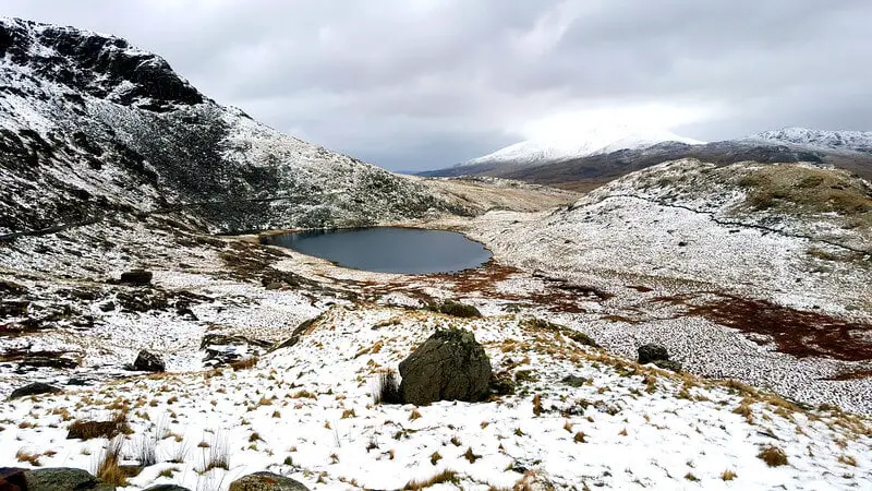
The path now steeply climbs up towards Llyn Glaslyn (the third and final lake).
Here you will see some of the grandest mountain scenery in North Wales and despite the steady climb you soon forget the hard work as you enjoy the views.

LLYN GLASLYN
From Llyn Glaslyn on out the track becomes a hard climb. Although you have walked almost three quarters of the route in terms of distance, you are only half way up the mountain, time wise. You will also have to walk across a lot of scree in order to reach the intersection of the Miners’ and the Pyg Tracks.
So stop and rest while you take in the landscape. Enjoy the dramatic view of Snowdon rising almost 500m above the glacial lake.
As you walk around the lake, look out for the ruins of a row of barracks on your right. This is where the miners used to stay during the week.


THE END OF OUR JOURNEY
Unfortunately, this is also where Gary and I had to call it quits
As we climbed further up towards the summit of Snowdon, the snowfall gradually increased. There were times we could barely see our hands in front of our eyes, as we were hit by snow-filled wind.
As we walked around Llyn Glaslyn seeking the steps up to the Pyg Track, Gary sunk knee deep into the snow.
Soon after we spotted a far better-equipped pair of hikers, removing their crampons. They confirmed that it would be impossible for Gary and me to reach the summit without specialist equipment. So sadly we had to turn back.


HAD WE CONTINUED…
In summer the stony steps will be far easier to spot. They are located just to the right of the old barracks. Follow them uphill until you join the Pyg Track.
From here the path is quite tricky to follow and can be easily lost in the mist. It is hard to climb and can be very slippery.

BWLCH Y SAETHAU
Looking across Llyn Glaslyn, to the left of the summit of Snowdon you will see Bwlch y Saethau (meaning ‘pass of the arrows’). Miners from Beddgelert used to climb to work over this pass with the help of iron chains fixed to the rock.
Legend has it that this is the place where King Arthur was struck by an arrow in battle. He was then carried to the shore of Llyn Llydaw, where a boat with three maidens came to take him away through the mist to Afallon (Avalon).

LLWYBR Y MUL
The path then zigzags up to Bwlch Glas, and on to the summit. It’s also a lot rougher, requiring the use of both hands in places.
Before the main road through Llanberis Pass was built, this path was used to carry copper up to Bwlch Glas and then down the other side of the mountain to Llyn Cwellyn. As you approach the Zig-Zags, keep well away from the open mine shafts on your left.
As you continue up into cwm, the mountains will appear to close in on you. This part of the path is known as Llwybr y Mul (mule’s path).

BWLCH GLAS
At Bwlch Glas you join the Llanberis Path and the Snowdon Ranger Path. The junction is clearly marked with a standing stone.
Along the right-hand side of the path you will see railway tracks running up the mountain. This is the Snowdon Mountain Railway, which has been carrying visitors to the summit since 1896 on the only public rack and pinion railway in the UK.

REACHING THE SUMMIT OF SNOWDON
From here the summit is a mere 20 minute walk away. Walking at a leisurely pace, you can expect to be on the summit in around a quarter of an hour.
The panorama that opens up in front of you is nothing short of spectacular. At least that’s what I am told! Gary and I certainly cannot wait to return in Summer, for a second attempt to reach the summit!
From the summit on a clear day you will be rewarded with fantastic views – 18 lakes and 14 peaks over 914 metres (3000ft) can be seen. Sometimes, you can even see as far as Ireland, the Isle of Man and the Lake District.
What is your favourite Candy in the World?
Comment below and let us know!
Did you Enjoy this article?
Share it with your friends and family on FACEBOOK, TWITTER AND PINTEREST


I have just returned from climbing Snowdon in the worse weather imaginable.
Gale force winds and heavy rain plus thick fog hampered our climb.
They were people walking back from the 2nd lake on the Miners path which is the route we took joining the Pyg path further up and the were on the verge of hyperthermia. I couldn’t believe how some people were dressed in shorts and T shirts in minus 1 temperature heavy rain fog and strong winds.
This Mountain demands respect.
We finally got to the summit and the queue at the trig point was small due to the severe weather conditions.
Our return was the easier Llanberis Pass eventually walking down to more sunnier and warmer weather as the storm cleared
Britain will continually awe me. What an awesome way to experience the outdoors in an unexpected time and still capture the amazing scenery of the west.